
Key Takeaways
- The Slave Route (La Route des Esclaves) is the actual road — not a reconstruction — along which over one million enslaved Africans were forced to walk between the late 17th century and 1865, from the Place Chacha auction block to the Atlantic beach.
- The route comprises six principal stations: Place Chacha, the Tree of Forgetfulness, the barracoons (First Quarter), the Zomai Enclosure, the Tree of Return, and the Door of No Return — each marking a distinct stage of the systematic psychological and physical dismantling of identity.
- The UNESCO Slave Route Project was launched in 1994 in Ouidah — but the proposal originally came from Haiti, not from Benin or UNESCO itself. The diaspora initiated its own commemoration.
- Twenty-three colorful sculptures line the route, most created by Beninese artist Cyprien Tokoudagba (1939–2012), whose internationally exhibited work translates Vodun cosmology into public monumental form.
- Every January 10th, tens of thousands of people walk the route in reverse — from the ocean back into the city — in a collective liturgical act led by Hounon high priests, symbolically undoing the forced departure station by station.
You are standing at Place Chacha, in the center of Ouidah. The road goes south.
There is nothing dramatic about it at first. A laterite road, red dust, morning light still low. Motorcycles pass. A vendor opens her stall. The city is alive and unremarkable around you. There is a square with a name — Chacha — and if you know whose name it carries and why, you feel the first weight of what you are about to walk into.
The road goes south. It is 3.5 kilometers to the ocean. You begin to walk.
This is the Slave Route of Ouidah — La Route des Esclaves. And unlike most things called a memorial, this is not a reconstruction. This is the actual road. The same laterite earth, the same direction, the same distance that over one million enslaved Africans were walked, in chains, between the late 17th century and 1865. The city has grown around the road. It has not grown over it.
What This Road Really Is
Every memorial in the world involves a choice: how much of the original place do you preserve, and how much do you create in its image?
The Slave Route of Ouidah involves almost no such choice. There was no decision to build a commemorative path in the location where the actual path once ran. The commemorative path is the actual path — maintained by the physical persistence of the city around it, by the inability of urban development to fully erase a road that 200 years of continuous use had pressed deep into the earth.
When the Beninese government and UNESCO inaugurated the memorial route in the early 1990s, they were not constructing something. They were naming something that already existed. The stations they designated — the places where specific things happened — were identified through oral tradition, local memory, and in some cases physical evidence. The monuments erected at each station are new. The ground beneath them is old.
This is what makes the Slave Route different from the memorials at Gorée Island in Senegal or Cape Coast Castle in Ghana — architecturally powerful places that sit on sites connected to the trade, but which are primarily colonial-era fortifications repurposed as memorials. In Ouidah, there were no great stone forts at the embarkation point. The infrastructure of the trade was made of people, pirogues, and this road. And it is still here.
The Deep History
What the Road Was (17th–19th Century)
In the 17th century, when European traders first established permanent commercial relations with the Hueda Kingdom of Ouidah, this road was a trade route. It connected the interior of the city — the commercial center, the royal compounds, the warehouses — to the beach. Goods moved along it in both directions. Agricultural produce moved south. European trade goods moved north.
Then the trade in human beings began to dominate everything, and the road's meaning changed.
By the late 17th century, the route from the commercial center to the beach was primarily a route of captive deportation. Coffles — groups of captives chained together — arrived in Ouidah from the interior after marches of days or weeks. They entered the city at what became the Place Chacha, were processed through the auction infrastructure of the de Souza commercial network, and were then walked south in groups toward the beach. This walk — which we now call the Slave Route — was the final leg of journeys that had begun in the interior kingdoms of the continent.
The route's geography was functional, not symbolic. It was the most direct path between the commercial infrastructure of the city and the embarkation point on the beach. The stations that existed along it — the holding areas, the trees, the enclosures — were operational elements of a logistics system, not rituals invented for the purpose of commemoration.
Only one element was deliberately spiritual: the forced circling of the iroko tree, which weaponized Vodun numerology against the captives in an attempt to disorient them before embarkation. Everything else — the darkness of the Zomai, the crowding of the barracoons — was the cold logic of processing a human cargo.
The System at Its Peak (1750–1850)
At the height of the trade, the road was never quiet. The scale of the de Souza operation during his peak years in the 1830s and 1840s — an estimated 10,000 to 15,000 people per year — meant that this road carried dozens or hundreds of captives southward on most days of the operating season.
European surgeons inspected the captives at Place Chacha. Company factors branded those selected with hot irons — the mark of the French East India Company, the Portuguese Royal Company, or de Souza's personal stamp. Groups were then organized by age, sex, and apparent physical condition and marched south under guard.
The walk took four to six hours for captives weakened by the marches from the interior and the time spent in the barracoons. Those who fell were beaten or dragged. Those who died on the road were left where they fell. Historians estimate that 20% of those who reached the beach did not survive the Middle Passage — dying during the ocean crossing before arriving in the Americas.
The End and the Silence (1865–1992)
The last documented illegal slave ship departed from Ouidah for Brazil in 1865. The road had been used as a deportation route for approximately two centuries. Then it became, simply, a road again.
For more than 125 years after the last departure, no official memorial of any kind existed on the route. The road continued to function as a south-running road through the city — used by ordinary commerce, daily movement, neighborhood life. The oral traditions of the community retained the knowledge of what had happened along it. The families of Ouidah knew. The Hounon priests who periodically poured libations at specific points along the route knew. But there was no arch, no plaque, no UNESCO-designated memorial landscape.
The silence of those 125 years is itself historically significant. It is evidence that the construction of official memory — the decision to name, designate, and preserve — is a political act that requires a specific political moment. That moment did not arrive in colonial Ouidah, where no colonial power had interest in commemorating the trade it had conducted. It arrived with independence, with democracy, and with the diaspora's growing demand to be recognized.
The Creation of the Memorial (1990–1995)
The first movement came in 1990, when the Beninese government — in the transitional period before full democratic elections — launched a project to commemorate the victims of the slave trade. The initiative was driven partly by internal political logic (Vodun Day as national holiday under Soglo in 1992), and partly by an international moment in which the global diaspora was demanding precisely this kind of recognition.
The route was inaugurated in its memorial form during the Ouidah 92 festival — a cultural event that brought together artists, scholars, and diaspora representatives from across the Atlantic world. The festival was the first public ceremony in which the route was walked as an act of memory rather than commerce.
In 1994, UNESCO officially launched the Slave Route Project — and chose Ouidah as its epicenter. The project's stated goals were not only commemorative but scholarly: to document the trade, to create educational resources across the Atlantic world, and to promote dialogue between the communities connected by the history.
What most visitors to the route do not know is that the UNESCO project was proposed by Haiti. Not by Benin. Not by UNESCO staff. The initiative came from the Haitian delegation at an international symposium, driven by the recognition that the diaspora's own history of origin required a physical anchor. The route you walk in Ouidah exists, in part, because the descendants of the enslaved insisted it should.
The Door of No Return was built the following year, in 1995. The route's 23 sculptures were commissioned over the following decade, most from Cyprien Tokoudagba (1939–2012) — Benin's most internationally celebrated Vodun artist, whose work brought the Vodun cosmological framework into the public monumental landscape of the route.
Walking the Route Today
On a dry-season morning in 2026, the walk from Place Chacha south to the beach is a study in gradients.
The city begins loud. Place Chacha is a functioning commercial square — vendors, motorcycles, the daily apparatus of Ouidah's market economy. The square is named for Francisco Félix de Souza. His house stood on its western edge. Today a monument stands in its place. The name on the square is not an endorsement. It is Ouidah's characteristic way of holding its history: present, visible, unresolved.
As you walk south, the urban noise diminishes. The houses become more sparse. The sound profile changes: fewer motorcycles, more birdsong, the distant percussion of the ocean beginning to register. At the one-kilometer mark, near the Tree of Forgetfulness, the road has already shifted from commercial to something else. Visitors arriving by car and approaching from the side miss this transition entirely. It is the most important part of the walk.
The route passes through living neighborhoods. This is not a fenced heritage corridor with security guards and interpretive panels. It is a public road through a city. Children play near the barracoon sites. Women sell produce from stalls adjacent to the Zomai enclosure. Dogs sleep in the shade of the Tree of Return. Life is continuous here, unpaused for memorial purposes. The consequence is that the route feels alive rather than museified — but it also means visitors must exercise the attentional discipline of a pilgrim rather than the passive reception of a museum visitor.
The 23 sculptures by Cyprien Tokoudagba and others are distributed along the route's 3.5 kilometers. They do not explain. They do not describe. They depict — in Tokoudagba's characteristic flat-perspective style, with the bold primary colors of the Vodun palette — figures of the pantheon, scenes of the crossing, forms that require a guide to interpret. Each sculpture is a station of contemplation for those who know how to read it, and an encounter with powerful visual presence for those who do not.
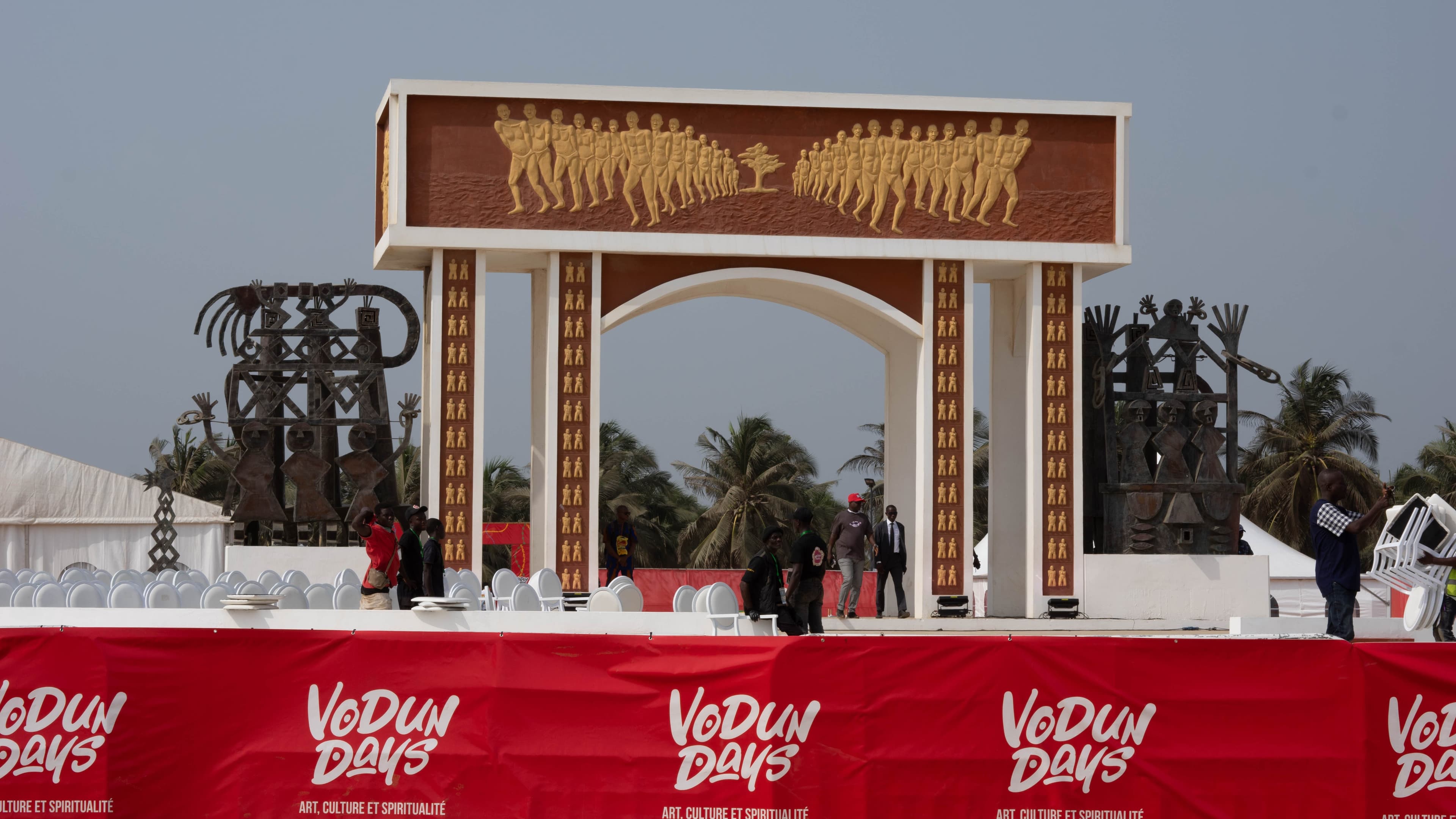
The road ends at the beach. The vegetation parts. The sky opens. The arch appears.
The Diaspora Returns
The route's most powerful use is the one that reverses it.
Every January 10th, in the ceremony known as the Return of the Children (Le Retour des Enfants), tens of thousands of people — local Beninese, diaspora visitors, government officials, pilgrims from Brazil, Haiti, the United States, the Caribbean, France — walk the route from the beach back to the city. The direction is reversed. The walk goes north, from the ocean toward Place Chacha, from the point of departure toward the city of origin. Each station is revisited: not as a site of trauma but as a site of reclamation.
The walk is led by Hounon high priests who pour libations at each station — palm wine into the earth at the Tree of Forgetfulness, water poured toward the ocean at the Tree of Return, offerings laid at the barracoon sites — calling the names of the unnamed, those who have no descendants, those who left no record of their lives. The liturgy of the walk is not written down. It is transmitted orally, ceremony to ceremony, generation to generation.
For diaspora participants, the route is often described as the most disorienting experience of their journey to Ouidah — not because it is frightening but because it is physically immediate. The laterite road is red. The sun is real. The distance is real. There is no glass between you and the history. You walk it in your body, in heat, with dust on your feet, and the ocean either ahead or behind you depending on which direction you move.
Many diaspora visitors describe the walk as the moment their sense of history changes from intellectual to embodied. The numbers — one million people, 200 years — become a road length: 3.5 kilometers. That distance is something a human body understands in a way a figure in a database cannot.
The Route in the Memory Tourism Landscape
The Slave Route occupies a distinct category in the global memory tourism framework: it is not a museum, a monument, or a heritage site in the conventional sense. It is a lived geography — a public road through a living city that has been designated as memorial space without being removed from ordinary life.
This is both its greatest strength and its interpretive challenge. At Gorée Island or Cape Coast Castle, the memorial experience is contained within walls. The visitor enters, experiences, leaves. The boundary is clear. On the Slave Route, there is no boundary. The memorial coexists with commerce, with traffic, with children playing and vendors selling and motorcycles passing. The visitor must do the interpretive work themselves — must hold the historical weight while moving through a space that does not pause for it.
This unfenced quality makes the route particularly demanding for diaspora visitors, who often arrive expecting the kind of contained memorial experience they know from other sites. They find instead a road. A real road, with real life on it. The emotional response this produces — disorientation, frustration, unexpected grief — is itself part of what the route was designed to facilitate. The captives did not walk through a museum. They walked through a city that was going about its business while they were being taken to the ships. The indifference of ordinary life to atrocity is part of what the route preserves.
For visitors approaching the Slave Route as an act of pilgrimage rather than tourism, the ethical framework that OuidahOrigins recommends is particularly relevant here: the route asks for presence, not performance.
The Reverse Walk as Liturgy
The January 10th reverse pilgrimage — the Return of the Children — has grown from a local ceremony into one of the largest diaspora gatherings on the African continent. In 2025, an estimated 450,000 people attended Vodun Days, with a significant diaspora contingent walking the route in reverse. The walk has no registration, no fee, and no fixed boundary between participant and observer. It is a liturgical act in the most precise sense: a collective, repeated, bodily practice that transforms the space it occupies.
For those unable to attend on January 10th, any walk of the route can be undertaken in reverse — from the Door of No Return back to Place Chacha — as a personal act of reclamation. The direction matters. The captives walked south. Walking north is undoing.
Contemporary Developments Along the Route
Since 2020, the infrastructure surrounding the Slave Route has transformed significantly, and understanding these changes is part of understanding the route's present reality.
The MIME Museum, inaugurated in 2025, stands near the midpoint of the route. It provides the interpretive layer that the route itself deliberately withholds — exhibitions, archives, and spaces for the historical context that the walk alone cannot deliver. The museum and the route are complementary infrastructure: one explains, the other is experienced.
The Dhawa Ouidah Hotel, a 4-star property by the Banyan Group, opened in 2025 within walking distance of the route. Its presence has generated ongoing debate about the appropriate relationship between luxury hospitality and memorial space — a debate that is itself part of Ouidah's evolving identity as a heritage destination.
The New Door of No Return, currently under construction, will create a second terminal point for the route, designed to accommodate the growing scale of diaspora pilgrimage. The original Door will remain in place. The relationship between the two — one intimate, one monumental — will define how future generations experience the route's endpoint.
The Spiritual Logic of the Route
The six stations of the Slave Route were not, at the time of the trade, understood as a spiritual sequence. They were operational infrastructure. But in Vodun cosmological retrospect — in the way Ouidah has processed its history through its spiritual frameworks — the route reads as a systematic dismantling of the self: a sequence designed to strip a human being of everything that constituted their identity before the ocean received them.
Each station corresponds to a specific type of loss:
Place Chacha is the loss of freedom — the transaction that makes a person property. The Tree of Forgetfulness is the attempted loss of memory — the past tense of identity. The barracoons are the loss of health and dignity — physical destruction as psychological warfare. The Zomai Enclosure is the loss of orientation — darkness, time, and language taken together. The Tree of Return is the resistance to all of this — the captives' insistence that at least the soul could not be purchased.
The Tree of Return is the theological hinge of the entire route. It was established by the captives themselves, supported by sympathetic Vodun priests — an act of spiritual insurgency against the machinery of erasure. Walk around the tree three times, and even if your body dies in the Americas, your soul will travel back under the Atlantic through the roots and re-emerge in the Sacred Forest of Ouidah. The "No Return" was always, in Vodun logic, provisional.
Every January 10th, when the route is walked in reverse, it is not simply a commemoration. It is the enactment of the Tree of Return's promise: the souls did come back. They came back in the bodies of the descendants who make this walk. The direction they walk — north, from sea to city — is the direction the roots carry souls home.
How to Walk
The Only Right Way: On Foot from Place Chacha
Do not drive to the beach. Do not start anywhere other than Place Chacha.
The walk is not exercise. It is the experience — a graduated transition from the noise of the living city toward the silence of the ocean, across the same ground, in the same direction. Arriving by car and walking only the last 500 meters to the arch is the memorial equivalent of reading the last chapter of a book.
Allow 90 minutes to 2 hours at a reflective pace for the full route. If you combine it with the Portuguese Fort (which is the natural starting point for historical context), allow a full half-day. On January 10th, arrive early and plan to be present for several hours.
The Six Stations: What Each Asks of You
| Station | What it was | What it asks now |
|---|---|---|
| Place Chacha | The auction block | Stand still. Look at the ordinary commerce around you. Try to hold both realities simultaneously. |
| Tree of Forgetfulness | Forced identity erasure | Many visitors walk around it in reverse — 9 times, counting down. Un-forgetting. |
| The Barracoons | Holding cells | Slow down. The site is marked but not staged. What you feel here is the weight of the unstaged. |
| Zomai Enclosure | Sensory deprivation | Enter the shade. Let the silence accumulate. This is the station that works through absence. |
| Tree of Return | Spiritual counter-ritual | Tie white cloth if you brought it. The ritual continues. The dead are still expected home. |
| Door of No Return | The embarkation | Stand on both sides. Face the continent. Face the ocean. The monument was designed for both directions. |
Practical Notes
- Guide: Official guides certified by the Ouidah Museum of History are available at Place Chacha and at the Portuguese Fort. Not mandatory, but transformative — particularly for the Zomai and barracoon sites.
- Best time: Early morning in any season. January 10th for the reverse procession. Avoid midday in dry season.
- Duration: 90 minutes (walk only) to full day (with Fort and stations explored).
- Bring: Water, sun protection, white cloth (optional, for the Tree of Return).
What Few People Know
The Project Was Proposed by Haiti
The UNESCO Slave Route Project is commonly understood as a Beninese or UNESCO initiative. It was neither. The proposal came from the Haitian delegation at an international symposium — diaspora representatives who argued that the transatlantic history required a physical anchor in Africa, not just in the Americas where the consequences had been borne. Haiti, the country born from the only successful enslaved people's revolution in history, proposed that the place of departure be formally recognized and commemorated.
The route you walk in Ouidah exists, in part, because the descendants of the enslaved insisted that it should. This is not a minor historical footnote. It reverses the typical direction of institutional memory — usually initiated by states or international bodies — and roots the memorial in the diaspora's own demand for recognition.
The Zoungbodji Excavation: Bones and Chains
Most visitors to the route encounter the barracoon site as a marked location with a memorial plaque. They do not know what was found when archaeologists excavated here in 1992, during the preparatory work for the Ouidah 92 festival.
Workers uncovered a mass grave. Bones — human remains — alongside iron chains and metal shackles. The site confirmed, in forensic rather than documentary terms, what oral tradition had long maintained: the mortality rate in the holding cells was real, and the bodies were disposed of here, with no ritual, no identification, no burial in any meaningful sense.
The Mémorial de Zoungbodji — the Common Grave Memorial — was built over this excavation. The bones were reinterred. But the existence of the physical evidence changes the register of the site: this is not a place designated to represent something. It is a place where the thing itself occurred and left material proof.
The Academic Debate You Should Know About
There is an honest and important intellectual controversy about the Slave Route's historical accuracy.
Robin Law — one of the world's leading historians of the Kingdom of Dahomey and the Ouidah slave trade — has argued in published scholarship that several of the sites designated by UNESCO do not correspond to historical reality. The "auction square" at Place Chacha, he argues, was not where auctions occurred — captives were sold at the entrances of individual slave traders' houses, not in a central market. The historical reality of the Tree of Forgetfulness and the Tree of Return, he suggests, is also contestable.
Law is not a denialist. He is a scholar arguing for precision.
The sites, he suggests, may represent a memory of the trade rather than the trade's actual spatial logic — a collectively constructed narrative that is emotionally and culturally true but not always geographically exact. This matters because it raises a genuine question that every serious visitor to the route should sit with: Is a memorial that is emotionally true but not historically precise a falsification, or is it a different kind of truth?
Ouidah Origins does not resolve this question. We present it because honest engagement with Ouidah's history requires holding the uncertainty. The route is real. The trade was real. The ground remembers. The precise location of every element may or may not be accurately designated. Both things can be true.
If You Want to Go Deeper
The Slave Route is the spine of Ouidah — every other pillar of the city's history connects to it. To walk it without context is to observe a geography. To walk it with preparation — with knowledge of what each station meant in its time, and what it means now — is to engage with one of the most concentrated moral landscapes on earth.
OuidahOrigins' Concierge service offers guided walks of the complete route with cultural and historical depth that transforms observation into understanding: access to the oral traditions held by the Hounon priests, interpretation of Cyprien Tokoudagba's sculptures at each station, and the option to walk the route in reverse on January 10th as part of the organized Return of the Children ceremony.
Plan your walk with our Concierge →
The Slave Route connects every major site in Ouidah. It begins at Place Chacha — the story of the man whose name the square carries. It passes the Tree of Forgetfulness and the Zomai Enclosure, each with their own deep history. It ends at the Door of No Return and the beach of Mami Wata.
Sources & Further Reading
- La Route de l'esclave — Wikipédia (FR) — History of the UNESCO project and its political origins.
- UNESCO Slave Route Project — 20th Anniversary — Official UNESCO documentation of the project's scope and goals.
- Sites marquants — UNESCO World Heritage Tentative List — UNESCO's formal documentation of Ouidah's memorial sites.
- SlaveVoyages Database — Vessel-by-vessel records; search "Ouidah" for the trade's documented scale.
- La Route des Esclaves — Africultures — Critical analysis of the project as transatlantic memorial from 1994 to today.
- Cyprien Tokoudagba — Wikipedia — The artist whose sculptures define the route's visual identity.
- Kingdom of Dahomey — Wikipedia — The political and military system that supplied the trade through Ouidah.
Frequently Asked Questions
Lire aussi
The door of no return
In Ouidah, the door of no return is much more than a simple monument. It embodies the last steps of a million Africans, marking a pain that still lingers.
The return of cultural treasures: Ouidah and the colonized legacy
The fight for the return of cultural objects from Africa raises essential questions about identity and collective memory. Ouidah, a symbol of this resilience, is at the center of this debate.
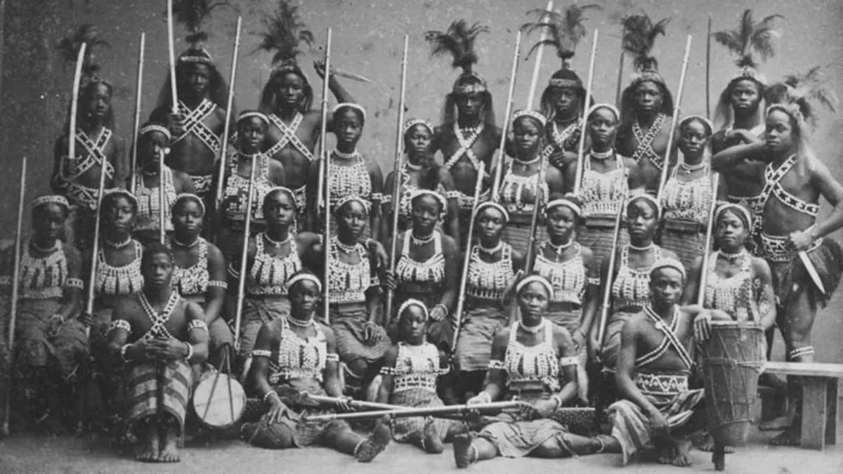
The Agojie
Encountering the Agojie in 1892, the French Foreign Legion met a formidable force. These women were not just warriors; they were a documented army that defied norms and shaped history.
Reading paths
The Slave Route
From the Atlantic slave trade to contemporary memory
Vodoun & Diaspora
How an African religion crossed the Atlantic
- Step 1· 12 minLe Temple des Pythons
Les origines du vodoun à Ouidah